Opal Creek Wilderness – Opal Creek and Opal Pool (#)

OPAL CREEK AND OPAL POOL

May 29, 2011

Info: Thank you Oregon.com for the info!!! (http://www.oregon.com/Hike_Opal_Creek)

Difficulty: An easy 4-mile hike traverses the old-growth forest to 30-foot Sawmill Falls. A longer, 7.1-mile loop extends upriver to Opal Pool and Jawbone Flats, a Depression-era mining camp.

Season: Open all year, but the route may be snowy or icy after mid-winter storms.

Getting There: From Interstate 5 exit 253 in Salem, drive on East Santiam Highway 22 for 23 miles to Mehama’s second flashing yellow light. Opposite the Swiss Village Restaurant, turn left on Little North Fork Road for 15 paved miles and an additional 1.3 miles of gravel. At a fork, veer left on Road 2209. Then drive 4.2 miles to the locked gate. Residents of Jawbone Flats are allowed to drive the dirt road ahead; others must park and walk

Fees: A Northwest Forest Pass is required to park here. The pass costs $5 per day or $30 per season. (You can get a pass here ahead of time —  I get the annual pass — http://www.discovernw.org/store_national-forest-recreation-day-pass-national-forests-in-washington-and-oregon-only_09944.html)  It can be purchased at a ranger station, an outdoor store or at the trailhead fee box.

Hiking Tips: From the trailhead gate, the pleasantly primitive road crosses Gold Creek on a 60-foot-high bridge, skirts dramatic cliffs above the Little North Santiam River, and winds through an old-growth grove as impressive as any found farther upstream.

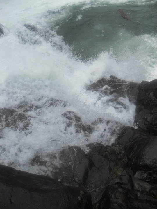
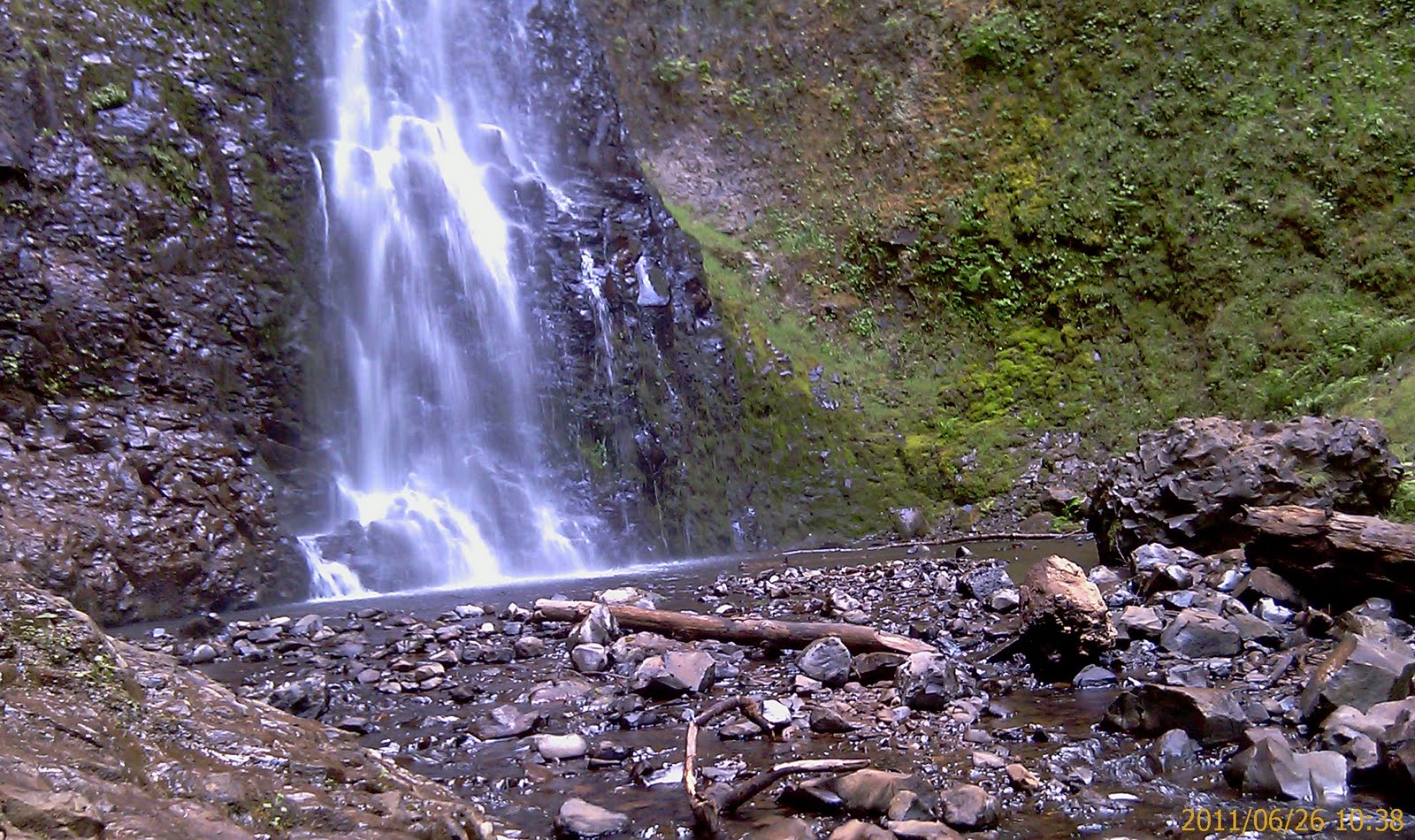
At the 2-mile mark, stop to inspect the rusting machinery of Merten Mill on the right. The mill operated briefly during the Depression, using winches from the battleship USS Oregon, but folded after two of the mill’s lumber trucks fell off the narrow canyon road. Now a camping area for backpackers, the mill site has one small empty building that can serve as emergency shelter. A short side trail behind the building leads to Sawmill Falls, a 30-foot cascade pouring into a deep green pool ideal for a chilly swim.

The route forks 0.2 mile beyond Merten Mill. Turn right across the river on a 100-foot bridge above a lovely gravel beach. The hike then follows the somewhat rough Opal Creek Trail left along the Little North Santiam River through woods where twinflower blooms and huckleberries ripen in July. After a mile, a sign points left 50 feet to Opal Pool’s scenic gorge.

To return on a loop, turn left, cross a footbridge at the head of Opal Pool, climb to an old mining road and keep left through Jawbone Flats, a well-preserved collection of 27 buildings dating from 1929-1932. Jawbone Flats has been donated to the Opal Creek Ancient Forest Center as an old-growth study center.

Respect the residents’ privacy by staying on the road. Dogs must be leashed here. On summer weekends, a tiny store in the settlement sells snacks, drinks and T-shirts. The center also includes several rentable cabins for $100-$300 that sleep 2-16 (for information call 503-897-2921 or check www.opalcreek.org).

An optional side trip for those who would to see more of Opal Creek begins at Opal Pool. When you reach the trail junction beside Opal Pool continue upstream 0.6 mile to a single-log footbridge. Along the way you’ll pass several small waterfalls. If you like, continue 0.9 mile upstream on a rougher trail to Cedar Flat’s trio of ancient red cedars, 500-1,000 years old. Near here, the Beachie Creek crossing, on a mossy log, is a good place to turn around. The trail peters out beyond this point.

Jawbones Flats is a Depression-era mining camp that now greets hikersHistory: Opal Creek’s ancient forest was thrust to fame in the 1980s by controversy over Forest Service logging proposals. National television crews and thousands of visitors hiked to Jawbone Flats’ rustic mining camp and scrambled over a rugged “bear trail” to view the endangered old-growth groves towering above this creek’s green pools. By the time Opal Creek finally won Wilderness protection in 1998 an improved path had been built to make the area more hiker-friendly. The new trail shortcuts from the Little North Santiam River to Opal Creek, making possible a loop trip to Opal Pool’s gorge and Jawbone Flats.

Geology: Miners at Jawbone Flats did not find commercial quantities of gold, and so they concentrated on nickel and other minerals instead.

Jenn’s View:I was wet and miserable. LOL. The only downside to the trail was that it was a “road” not a hiking through a forest type trail until you get to the bridge. It was a pretty interesting hike though. We did end up at an “old town” type of place and ate our Subway Sammich!  Just watch for the crazy shuttle van that transports people who rent the cabins from the parking lot. At times I wanted to hop on!  I know we encountered a mine but the entrance was blocked. 🙂


The Falls and the area were actually beautiful. I will try this hike again. It will be at the bottom of my list unless someone wants to shuttle me up to Opal Pool and then I will hike all of Opal Creek area 🙂

Here is the map I downloaded from Oregon.com. Same website that I got all that information from. So we started at the Lock Gate. I believe that’s the parking area. We “walked” on the road towards Opal Pool and hit the bridge. It was a very long walk but Joyce, Terri and I made it a blast.

We found a little area that we pretended (Okay, just Joyce) that she was looking for Edward Cullen from Twilight. She’s so silly.

Well, here are a few of my favorite shots:

This slideshow requires JavaScript.

Santiam State Forest – Lower and Upper Butte Creek Falls (#8)

LOWER AND UPPER BUTTE CREEK FALLS
Scotts Mill, Oregon
May 7, 2011

Info: (http://www.waterfallsnorthwest.com/nws/falls.php?num=4443) This gorgeous 78 foot waterfall is the highlight of the Butte Creek Falls trail system, and the view from the viewpoint makes it all that much more impressive. The falls are viewed from atop a rocky promontory, jutting 150 feet above Butte Creek, which makes a wide 180 degree turn around the obstacle. The trail actually continues down the ledge, clinging precariously to the edge of the cliffs at points (not something I wanted to try in the rain), eventually reaching the base of the falls, and Lower Butte Creek Falls, which are located immediately below the large plunge pool of Butte Creek Falls (the lower falls are, however, very difficult to clearly see). Flowering trees can be seen adorning the basin in the spring months, some of which stand at perfect locations to frame the waterfall. KATU did even a story on these falls. http://www.katu.com/younews/99994229.html
Difficulty: Easy but careful it’s slick                                                                   Distance: unknown
Jenn’s View:
I loved it even though it rained and was wet, slick, muddy —  I loved this area. It’s easy and relatively flat except in areas that I had to get great pictures but otherwise a great trail for kids and families of all ages. Just be super careful when you get to one of the falls. The ledge is quite high and slick. A dog had fallen off the ledge and died. Was on KATU news. 😦  You must go in SPRING to get the full waterfall effect. Otherwise, the waterfall display is minimal and not so grandeur! Like most waterfalls in Oregon.
Directions:
Upper/Lower Butte Creek Falls are northeast of Salem, OR.

  1. On I-5 take Salem exit 256 (Market St. / Hwy 213)
  2. Head east on Market St. (note HWY 213 sign)
  3. At the second light turn left on Lancaster (HWY 213 sign).
  4. After 1.3 miles turn right on Silverton Road.
  5. In another 10 miles (while in Silverton) you will reach a three-way
    stop sign. Turn left to remain on HWY 213
  6. Turn left on 1st St.
  7. Turn right on Oak St. (HWY 213)
  8. In another 4.8 miles turn right onto Scott’s Mills Road NE
  9. In another 2.7 miles (while in Scott’s Mills) turn right onto Crooked Finger Rd.
    (go past park for McKay Falls)
  10. After 9.2 miles Crooked Finger Road turns to gravel.
  11. Note your odometer or reset your trip odometer at this point.
  12. In 2.1 miles turn left onto road CF400 (but not marked as such)
  13. In one-tenth mile the road forks. Take the right fork.
  14. In another 1.8 miles there will be a rest area with parking on the left.
  15. Trail to the falls starts here.

_______________________________________________________________________________

 I had such a crappy day the day I did this hike. The night before, I wrecked the front end of my car and then got it towed at an apartment complex and had to wait till the next morning to get it out! I was feeling quite depressed and so I loaded up the rental car that I got and took off. I printed this fall (and many others) from Oregonwaterfalls.net.  But my rental car sure did get me there!
 Here is my poor wrecked car before they hauled it away 😦
 It was sunny when I left but sure did start to pour when I got there. Glad I brought my ski jacket to keep me warm. I still loved it though! The road to get there was pretty neat.  The sun shining through the trees…makes a great photo opportunity.

You’ll see the trail head to the left of you. The trail is pretty easy but be careful of the slippery rocks and mud.

The first fall I came to was Upper Butte, I think. he he. I don’t know, a fall is a fall….

You can walk down this little path to get behind the waterfall.  The water level was a little too high and it was quite muddy, so I stayed away from it. 🙂 I’m not dumb.  Did discover a little grave site.  Didn’t really see an actual grave, just the crosses.

For Spring in Oregon, it was still very cold. The jacket did get soaked but still kept me warm :).  Start traveling down the trail and you will always hear the creek. Tons of water going through.  I think Spring is a great time to go since the waterfalls are at their best display. Unfortunately, it is so wet and cold in Oregon that it deters me from actually going out and seeking them.  But once I get the bug to go, I go!

There was one part of the trail that I really wanted to get a picture of but had to practically slide down this hill and hopefully not fall in.  Pictures from my phone DOES NOT do it justice!

 It was pretty close to Lower Butte so climbed up the hill and voila, hit the next falls.  Like I said, easy trail, relatively flat…you can trail run this.

Me being a bit of a dare devil.  The cliff is pretty high but heights really don’t scare me. 

Of course Pics for my Facebook wall…he he

The trail back towards the car…you see interesting things. Someone made a chair to sit on. 

After returning to my car, I was looking for another hike to do.  Started following this road to get to a lake.

Unfortunately the higher I went, the more snow I saw until I got to the point that this rental car would not be able to go through. he he.

The END… 🙂
Go check out Santiam State Forest – Abiqua Falls blog dated October 23, 2011.  It is less than a couple of miles from here and the Fall is amazing!

Opal Creek Wilderness – Salmon Falls (#7)

SALMON FALLS PARK

 April 17, 2011
Info: http://www.co.marion.or.us/PW/Parks/descriptions/salmonfalls.htm)  Purchase of this area, with the assistance of Land and Water funds, was made to preserve an outstanding scenic site. The area is forested, and at the falls site, the Little North Fork of the Santiam River plunges over the rock outcropping about 30 feet to a pool beneath. Only minimum development of the popular area has been undertaken. Emphasis has been placed on preservation of the natural beauty of the site. The Bureau of Land Management owns land on two sides of the park and is interested in ultimately developing the entire area. Facilities at a Glance

  • 22.62 Acres
  • Picnic Tables
  • Fishing
  • Water Activities
  • Hiking Trails
  • Fire Pits
  • ADA Restroom

Hours
8:00 a.m. to Sunset

Directions:
  • On I-5 exit onto Hwy 22 and head east towards Stayton
  • In 22 miles – at second yellow light just east of Mehama – turn left onto North Fork Road SE
  • At milepost 13.6 turn right onto Elkhorn Drive SE
  • After ½ mile park on the left to access Little N. Santiam Trail No. 3338
    at the Opal Creek Scenic Recreation Area

Jenn’s View: Great hike for the family…If you travel up the path a bit, there is an area where you can go swimming. I bet it has a lot of people here during the summer. I remember pulling off to the side of the road, the trail was right there, and boom the waterfall was right there as well. Had to do a little climbing but VERY little.  The trail continued and would be an excellent “beginners” trail running area. Highly recommend even with small children. Just be careful of the water.
*********************************************************************************

It was pretty cold but just dress in layers and should be great.

The trail was relatively flat and leads you straight on top of the falls. You see all these little wooden bridges. When I told TJ we had to get back soon because we had to drive to Hillsboro for Grandma’s and Auntie Joyce’s birthday, that’s when he got all “pissy” and didn’t want to hike no mo’. 😦

The top of the falls did have a sign stating something about swimming at your own risk. he he

There are quite a few waterfalls around this area. Check out Opal Creek Wilderness blog. May 29, 2011 to get to Opal Pool or Henline Falls blog dated May 30, 2011 and Henline Trails dated May 21, 2011

**************************************************************************************

JUNE 23, 2012

Went and re-visited this on my way to Nasty Rock Hike – which by the way I did not do. I ran out of time. Scott was on his way to my house and I had to do the dishes.

The water level is real low at this time compared to what I had seen back in April 2011. 🙂 I had originally thought this was Elkhorn Falls but I was wrong. I even took a picture of the sign so this is what I assume is Salmon Falls Park.

Oh My goodness, I would NEVER use the bathroom. One thing, the lock is on the outside and it looked pretty gross in there…I was too scared. I’d rather pee outside.

Salmon Falls Park Salmon Falls Park Salmon Falls Park Salmon Falls Park

As you can tell by the picture, the water level is extremely low

Opal Creek Wilderness Salmon Falls Park

Opal Creek Wilderness Salmon Falls Park

Opal Creek Wilderness Salmon Falls Park

Go check out the other No Hikes Hike I just did around the area. Great place to take the kids for the day and see what wonderful areas Opal Creek Wilderness has to offer.

NORTH FORK PARK: https://oregonhike.wordpress.com/2012/06/23/opal-creek-wilderness-no-hike-hikes-north-fork-park/

SULLIVAN FALLS: https://oregonhike.wordpress.com/2012/06/23/opal-creek-wilderness-no-hike-hike-sullivan-falls/

Columbia Gorge – Wahkeena Falls Loop Trail #420 (#5)

WAHKEENA FALLS LOOP
May 31, 2010
Info: (http://www.columbiariverhighway.com/hiking/wahkeena_falls.htm) Wahkeena Trail #420 climbs steadily from the start. The path is wide and has several switchbacks. Wahkeena Falls has a height of 242 Feet. After the falls is the Perdition Trail #421 and has been closed since the 1991 fire and 1996 slides. Stay right, and you will come to a junction with two lookout trails. The trail to the right leads to Lemmon’s Viewpoint. The trail to the left leads to Monument Viewpoint. On the main trail, hike up to Fairy Falls. Restrooms are available at the trailhead during the summer season.
Difficulty: Moderate                                                                            Distance: 5.7 miles
Jenn’s View:
Joyce and I loved this hike. There are quite a few different trails but we took the one that lead us to Multnomah Falls.  It was a great work out AND so much to see and enjoy. Waterfalls are my most favorite things to look for. You actually get to see 5 different waterfalls on this trail. OHHH, this was the time I got a call from Washington County Police Department stating that Makaila was pulled over on TV Highway. She didn’t have her license at that time.  I told the cop that she must have stolen my suburban and was joyriding. I had to call Angela, my niece, to grab the burb and take her to Grandma’s house. She had the ticket drop and had to attend a safe driving course. hahahahaha!
So the first fall you come to is Wahkeena Falls which is the main picture (above) for this page.
Part of the river bed of Wahkeena Falls
So from the beginning of the trail, you can see the first bridge to the falls.

We got to the bridge and past the bridge is a rock crop.  Joyce thought she was funny and wanted to “pretend” she was rock climbing. he he.

Rock Climbin’ Joyce

After the steady climb, you reach Lemmons Viewpoint. Here Joyce decided she was “Ariel” from the little Mermaid. God, she’s weird!

We continue on and you are hiking right next to the river bed that feeds Wahkeena Falls.

The 2nd Fall you come to is Fairy Falls. This one was small but I thought was the prettiest of them all.

Next fall is Ecola Falls. Couldn’t really get up to close but you can see it from the trail. This was on our down, closer to Multnomah Falls.

The trail heading towards Multnomah was icky but cool.  At one point, you are walking under a cliff. The trail was wet and muddy but beautiful because you are walking next to the river.

Too bad it’s not deep enough to river raft.

The 4th fall is called Weisendanger Falls (don’t ask – I don’t know how to pronounce it either!).

Of course more pictures of the river / creek.  I’m so happy my little ELPH camera can take such great pictures. Too bad I killed the camera on a hike in the future (2011 hikes)

And of course the last and final falls was Multnomah Falls.  We running down Multnomah Falls trails, we ate our McDonald’s cheeseburgers that we got before getting to the falls.  While eating our burger, a little kid spotted our burgers and told his mommy we were eating McDonald’s. Joyce, being Joyce, told the little kid that McDonalds is at the top of the falls! LOL

Highly Recommend this trail! Make sure to do it in the late spring. It’s not too hot and the lighting is perfect to get pictures of the falls.

Silver Falls – Feb 2010, May 2010, June 2011 (#1)

SILVER FALLS
Silverton, OR
Info: (from http://www.oregonstateparks.org/park_211.php). Nestled in the lower elevation of Oregon’s Cascade Mountains lies a temperate rain forest. It is here that the Trail of Ten Falls/Canyon Trail. The Canyon Trail and the falls descend to a forest floor covered with ferns, mosses, and wildflowers. You will also find stands of Douglas fir, hemlock, and cedar. While thousands visit the park every year, it is large enough for you to find quiet places to sit and watch for birds.The Canyon Trail is a nationally recognized trail system that leads hikers along the banks of the north and south forks of Silver Creek. It takes you to 10 majestic waterfalls, ranging from the grand South Falls (177 feet), to the delicate Drake Falls (27 feet). Four of these falls have an amphitheater-like surrounding where you can walk behind
the falls and feel the misty, crisp spray.
 

JENNS REVIEWS: I highly recommend this trail. It’s easy (steep stairs and a slight incline near South Falls) and I love it. How can you beat seeing 10 waterfalls – C’mon! Only thing is — THE CROWDS! It’s a hot tourist trap and on hot summer days or even good sunny days, the crowds are annoying.  Recommend going mid week if you can and I do recommend trail running this but start early before the crowd. There is a parking area that you don’t have to pay but it’s very small.
First trip: February 21, 2010
So this was a treat. We had one “sunny” day and took advantage of it and decided to go hiking. This was the first trip hiking after a LONG stench of no hiking. Took Makaila and my good friend Terri along. We did the first loop along at South Falls with a large crowd taking advantage of the sun. We took a little detour and found a small path that lead to a small waterfall.
Terri taking a picture with her phone
Continued down the paved trail to South Falls. Unfortunately, there was ice on the trail that I think Terri slipped. Thank Goodness she didn’t get hurt but we struggled with the incline. There were quite a few people who slipped though.
OKEE, soo using my camera phone and Makaila’s crappy camera..Here is what we have on our very first trip.
Behind the South Falls
OK, it’s February and Kaila is wearing shorts?!?!?!
Somewhere there is a fall. Not sure which one though
Pictures of our trip and the first addiction to hiking. 🙂
Next Visit: May 21, 2010
The next visit to Silver Falls, I was armed with a little better camera and this time brought my sister Joyce and my other daughter Alesia.  This was more a picture opportunity of us than it was taking nature shots.
I honestly can not remember this trip. LOL. I do remember how silly my daughter was that day.
Left to Right: Joyce, Alesia, Me
Told ya she was being silly
I actually did get a “nature” picture
Next Next Visit: June 26, 2011
Now that I am in better shape, I decided to trail run the whole loop at Silver Falls. Started early in the morning to beat the crowd and parked at the North Falls parking lot. This parking lot, as well as South Falls Lot has a daily fee use of $5.  Total loop is approximately 8.7 miles. When I got back the lot was packed and still saw people looking for a parking spot.  I ran most of the trail but still stopped to take the opportunity to take pictures.  Now, most of the pictures that I take are from my camera phone.  I use to have a little elph camera but dang it, dropped it so many times it finally broke. And my luck the warranty expired a few weeks AFTER I broke it.

All these photos were taken from my HTC HD2 phone. Yup, ruined that phone that day too. 🙂

Next…

As you can tell…tried to remember to take a picture of the signs because each fall to me looks the same. 🙂

So, I took a picture of the ferns because I was actually waiting for this couple to finish taking pictures of the falls so I wanted to look busy. This is what happens when you want to look “busy”.

I wonder why I didn’t capture the next trail’s sign.  Either I missed it or there were too many people in front of it.

I promise that’s it! I will always do a return visit. Gotta take my family, out of town guests, blah blah blah through this gem. Hey, it’s like Multnomah Falls – must see in Oregon.

***********************************************************

JULY 22, 2012

Took Scott to Silver Falls for the first time. He absolutely loved it despite the many people there. It wasn’t as crowded as I have seen it but still pretty crowded.

Some new shots. My favorite to shoot was Lower South Falls